Canada:Marine Navigation Chart 86.0
Paid Version
Publisher Description
Canada:Marine Navigation Chart - Marine navigation & Route assistance with Voice Prompts - Never get lost again!!
GPS Marine Charts App offers access to charts covering Canada & USA waters (derived from CHS data). Only marine GPS app to have route assistance with Voice Prompts for marine navigation. It has route manager to create new boating routes or import existing GPX/KML routes. It supports Nautical Charts course up orientation.
Please visit
http://gpsnauticalcharts.com/main/ca-nautical-charts-by-folio.html for
complete list. If you don't find the chart for Canada , please contact us at support at gpsnauticalcharts.com.
(Includes coverage for Trent Severn Waterway incl. lake Simcoe etc.)
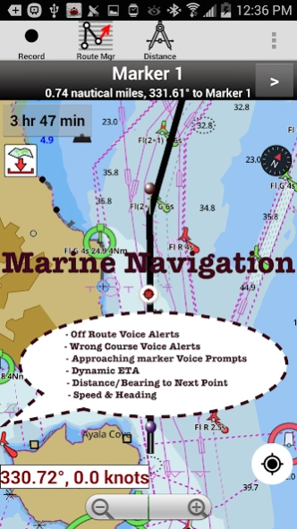
* Voice Prompts for marine navigation (requires GPS )
-prompts when approaching a boating route marker
-Continous distance and ETA updates
-Alerts when sailing/boating off route
-Alerts when boating in wrong direction
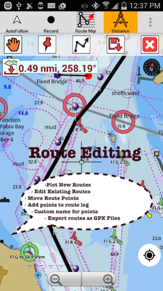
*Route Editing/Creation
-Create routes from scratch
-Edit existing GPX/KML routes.
-Add custom description to any route point.
-Drop markers along route.
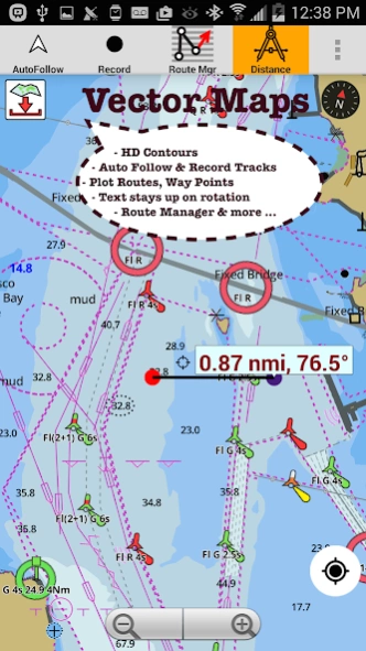
* Offline charts derived from UKHO data.
-Visually draw area to download
-Textual search
-Catalog (By state, region and coast guard district)
-Charts reprojected for WGS84 datum
*Seamless chart quilting of marine charts
*Distance Bearing tool
*Create custom way points
- Using GPS
-Select point on map
-Manually enter latitude & longitude coordinates
** Advanced NMEA Instrumentation
-AIS over TCP/UDP
-Wind speed, direction, temperature, depth, GPS over NMEA
*Pan/Zoom/My Location
* Record Marine GPS tracks
* View tracks overlay
* Live track animation
* Track analytics/stats
* Export GPX tracks.
-Export to SDCard
-Share GPX trakcs with friends/View on Google earth.
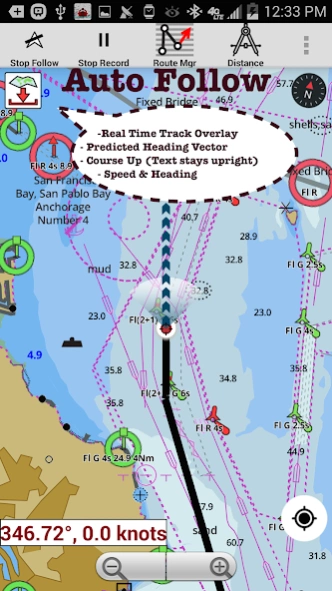
* Auto Follow Mode (Course up)
-Continuously updates boat's location on chart
- Adjustable update frequency
*Switch basemap to satellite imagery, street maps etc.
Sample Nautical Charts (please visit http://www.gpsnauticalcharts.com/ for complete list)
Pacific Coast - Vancouver Island East & West - Haida Gwaii
Great lakes Canada and St. Lawrence river
Rainy Lake and Lake of the Woods
Gulf of St. Lawrence South
Trent-Severn Waterway
Labrador Coast
Lac Saint Jean
Rideau Canal - Ottawa River
Newfoundland East and South
Lakes and Rivers of British Columbia
Lakes and Rivers in Manitoba and Saskatchewan
Lakes around Georgian Bay
Quebec to Anticosti Island West
Gulf of St. Lawrence North - Newfoundland West
Alberta Lakes
Nova Scotia South - Bay of Fundy
BALSAM LAKE
BALSAM LAKE TO/À BOLSOVER (LOCK/ÉCLUSE)
BOLSOVER (LOCK/ÉCLUSE) TO/AU LAKE SIMCOE
CAMERON LAKE
CHEMONG LAKE
ÉCLUSES DE HEALY FALLS LOCKS TO/AU RICE LAKE
LAKE COUCHICHING - LAKE SIMCOE TO/À COUCHICHING LOCK/L'ÉCLUSE DE COUCHICHING
LAKEFIELD
LAKEFIELD LOCK/ÉCLUSE 26
LAKEFIELD TO/À BURLEIGH FALLS
LAKE SCUGOG
LAKE SIMCOE
PETERBOROUGH TO/À LAKEFIELD
PIGEON LAKE
RICE LAKE
RICE LAKE TO/À PETERBOROUGH
STONY LAKE
STURGEON LAKE
Lake Erie Lac Erie
Lake HuronLac Huron
Lake OntarioLac Ontario
Lake OntarioLac Ontario, Western PortionPartie ouest
Lake St. Francis
Lake SuperiorLac Superieur
Vancouver Harbour, Central PortionPartie Centrale
Vancouver Harbour, Eastern PortionPartie Est
Vancouver Harbour, Western PortionPartie Ouest
Vancouver IslandIle de Vancouver, Juan de Fuca Strait toa Queen Charlotte
Strait of Georgia
BARRIE
BATAWA LOCK / ÉCLUSE 4
BEAVERTON HARBOUR
BENSFORT BRIDGE TO/À PETERBOROUGH
BIG CHUTE
BIG CHUTE MARINE RAILWAYS BER ROULANT
BIG CHUTE TO / À PORT SEVERN
BOBCAYGEON
BUCKHORN
BUCKHORN TO/À GANNON NARROWS AND/ET HARRINGTON NARROWS
BURLEIGH FALLS
BURLEIGH FALLS LOCK/ÉCLUSE 28
BURLEIGH FALLS TO/À BUCKHORN
CAMPBELLFORD LOCK / ÉCLUSE 13
COOK'S BAY AND/ET HOLLAND RIVER
COUCHICHING LOCK / ÉCLUSE 42
COUCHICHING LOCK TO BIG CHUTE ÉCLUSE COUCHICHING À BIG CHUTE
CROWE BAY LOCK / ÉCLUSE 14
DOURO LOCK
FENELON FALLS
FRANKFORD LOCK
GANNON NARROWS TO/À BOBCAYGEON
GLEN MILLER LOCK
GLEN ROSS
About Canada:Marine Navigation Chart
Canada:Marine Navigation Chart is a paid app for Android published in the Geography list of apps, part of Education.
The company that develops Canada:Marine Navigation Chart is Gps Nautical Charts. The latest version released by its developer is 86.0. This app was rated by 1 users of our site and has an average rating of 5.0.
To install Canada:Marine Navigation Chart on your Android device, just click the green Continue To App button above to start the installation process. The app is listed on our website since 2016-06-19 and was downloaded 14 times. We have already checked if the download link is safe, however for your own protection we recommend that you scan the downloaded app with your antivirus. Your antivirus may detect the Canada:Marine Navigation Chart as malware as malware if the download link to com.skiracer.nautical_astore_can is broken.
How to install Canada:Marine Navigation Chart on your Android device:
- Click on the Continue To App button on our website. This will redirect you to Google Play.
- Once the Canada:Marine Navigation Chart is shown in the Google Play listing of your Android device, you can start its download and installation. Tap on the Install button located below the search bar and to the right of the app icon.
- A pop-up window with the permissions required by Canada:Marine Navigation Chart will be shown. Click on Accept to continue the process.
- Canada:Marine Navigation Chart will be downloaded onto your device, displaying a progress. Once the download completes, the installation will start and you'll get a notification after the installation is finished.
